Saturday, 1 May 2010

Packrafting Verde River with access through Mazatzal Mountains, Arizona


Overview
:

This was a packrafting trip in the Mazatzal Mountains in central Arizona including a float on the Verde River between East Verde River and the landing strip. The trip was a loop from where I parked my car at the end of FR 406 from Doll Baby Ranch Rd, W out of Payson. I took two and a half days to cover 51 miles: 8 on trail, 7 off trail, 14 floating, and 20 hiking back on a "trail" (usually nothing more than deceiving cairns!). Below is a two-part Video Journal, followed by Trip Details, New Gear Systems, Natural History Highlights, and Photo Gallery.


Video journal: Packrafting the Verde River accessed by Mazatzal Mountains, Arizona.

Hike:

There is a good place to park the car and camp where the road is gated. Beyond that point the road continues, closed to public traffic but open to foot-travelers. The first ~5 miles follow this dirt road. Just before meeting the East Verde river, a sign points to Bull Spring trail to the left. Following that trail takes you up to the ridge line that parallels the East Verde on its South side all the way to the Verde River. Due to a bad case of trail blindness, I didn't pay careful enough attention and arrived at the ridge further East than intended - a fact I didn't realize until a couple of topographical surprises alerted me that I wasn't where I thought I was!

The Mazatzals are a very lumpy bunch of mountains in some places, requiring some very precise map reading at a small scale to keep on track. However, in general, the ridge is easy to follow even if you end up on the wrong hill a couple times. Mostly the brush is easily traveled - the biggest impediment being "Cat Claw" (Acacia greggii). In places there are some fun rocky high points requiring some clambering near a steep drop. The rock is occasionally limestone, which I found to be much more open with respect to brush than other substrates.

From the river, I followed trails leading to Bull Springs trail, and took Bull Springs trail back to the road. The trail was very difficult to find from the river. I saw no obvious beginning, but I just hiked up into the hills and found it pretty soon. The trails have several bifurcation points with sometimes-misleading signs requiring some accurate map assessment. I found hiking on these trails can be much harder than hiking off trail. When you are on the trail, the hiking is fast, but it quickly disappears into heavy brush while you wander around looking for cairns. Hiking off trail, I generally get onto ridge lines as quickly as possible where brush is less dense and navigation is easier. Bull Spring had plenty of water, although I made it the twenty miles on my five liters.

Float:

The Verde River was at about 350-500 cfs. (Camp Verde read 350 while Horseshoe Reservoir read 600). This flow was low for most boats, but optimal for a packraft. There were two rapids that might be called class III, though they were very easy to plow through. Mostly there were frequent wave trains and fun small channels to run through over sand bars, usually leading into a fun little section of rapids. Good fun without being scary. Paddling constantly I averaged 3mph, so it was not a fast river. The flat sections were very slow. The takeout is easy to spot if you pay good attention to your progress on the river. On the right (W) bank there is a well traveled trail dropping into the water to ford across, connecting with the trail I ascended back through the mountains. There are two orange spray painted dots on the rock to mark this point.

A packraft could probably run this river down to 250cfs, although there would be some butt bruises. For the record, the East Verde was far too low for floating for those of you crazy enough to want to do so!

New Gear Systems:

Hobo Stove! The morning of the drive I butchered a tin can to pile twigs in and boil water with a small contained fire. It worked great! The design could use a better air-drawing system, but it proved that one need not carry fuel when there is fuel all around! (video of hobo stove below)


Natural History Highlights:

#1: Caterpillar Parasitoidy by Wasp!: This is a real treat! This wasp, about 4 cm long, has paralyzed a caterpillar and is carrying it beneath its body. The wasp belongs to a parasitic group in the Hymenoptera, the Apocrita (Hymenoptera = wasps, bees, ants). This one appears to be of the family Braconidae, most of which are endoparasitic--laying eggs inside the larvae of butterflies, beetles, and flies. This one appears to be lacking an ovipositor, a long apendage that drills into the body of the host to deposit eggs. So it may be one of the early lineages within the Braconidae that are ectoparasites, and it is carrying the caterpillar back to its hole where it will chop it up and feed it to it's own larvae!


#2: Flame Mariposa (Calochortus kennedyi): A very rare and beautiful Lily! (ID based on Cabeza Prieta Natural History Association - Sonoran Desert Plants page online.)


Photo Gallery:

Claret Cup Cactus (Echinocereus triglochidiatus): Species ID based on Google searches.


Claret Cup Cactus (Echinocereus triglochidiatus): Species ID based on Google searches.


The Tarp set up using two trees

Beneath the cozy tarp with life vest as pillow

East Verde meeting some gorge


White and black heron (where the heck is my bird book!?)


Tarp set up using one tree and one bamboo stick


Glassy section of the Verde. Some rapids shown in the Trip Journal at top.


Flame Mariposa (Calochortus kennedyi): A very rare and beautiful Lily! (ID based on Cabeza Prieta Natural History Association - Sonoran Desert Plants page online.)


Fouauieria splendens and Prickly Pear


Verde River with Squaw Butte in center-left-distant.


Coati tracks!


Diamond Back Rattler! My first rattler encounter--it's rattle was unmistakable!


My second rattler encounter moments later! Same species, but completely different behavior.


Bull Spring in all its glory! Apparently this is some of the nicest looking water you can find in the Arizona backcountry.


40 miles down, 11 to go!


Exhausted and happy camped next to the truck.

Tuesday, 25 August 2009

Trip 3: Birch Creek to Mastodon Dome and Eagle Summit

Trip rating: 3/5
Dates: 11 – 13 July 2009
Duration: 3 days
Total miles: 47.8 miles (21.8 hiked, 26 miles packrafted)
Trip members: Ty Taylor and Marielle Smith
Start point: NE of Fairbanks, mile 94 of Steese Highway (Birch Creek access road)
End point: Berry Camp access road on Steese Highway
Trip synopsis: Floated 26 miles down Birch Creek and hiked alpine ridgeline to Mastodon Dome. Intended to continue along ridgeline to Eagle Summit and cycle back to car via the road, but instead took an earlier ridgeline down from Mastodon Dome to Berry Camp access road. This trip might merit a score of 4/5 if the water was a bit higher and the sun a bit less ruthless.
River class: I-II
Map:


Trip route: Birch Creek headwaters to Great Unknown Creek. Hike to Mastadon Dome and out mine road (we had planned to hike back to the road via Eagle Summit, but were too beat).


Trip journal:


View of the massive burn along the Steese on our way in. Fireweed blanketed the charred hillside with a spectacular purple.


DAY 1
TY: We hid two bikes off the Steese Highway in some bushes, locked to an alder, at Eagle Summit to cover the 13 miles that would separate us from our car when we completed the ridge-top hike to the road. We were looking forward to the exhilarating, mostly downhill bike ride in the midnight sun to cap off the trip. We parked the car at the Birch Creek headwaters next to some plaques with some simple words from Tim Palmer in “Lifelines: the case for river conservation,” appropriately putting our movement into ecological context:


“Passions run higher on rivers. Life seems more vital. On a river, it’s easier to believe in the power of nature, in the water cycle, in the chain of life, in the flow of nutrients down to the sea, in the fact that we are made from earthly elements and when we die those elements go back to the ground and feed some other life.”


I felt something of those words when filtering water from alpine seeps, savoring the earthy cool flavor and feeling how a piece of the land and sky becomes me and travels across itself.

The headwaters were too bony for floating so we waded from rocky shore to shore, crossing some beautifully imprinted and good sized grizzly tracks as we worked our way to deeper water. We were antsy to float and probably put in earlier than we should, resulting in bumping along the rocks and constantly getting out to drag the boats through shallows. It was, however, great manoeuvring practice! For the first five miles we spent about a third of our time out of the water, a ratio which gradually improved as we approached the Harrington fork, the river’s first substantial fork.


Ty wading across an early stretch of Birch Creek


On a bend, a large raptor circled over us calling out a long raspy “peeeeewww”. Further down, we scared a moose and her young calf away from the water's edge. The mother disappeared in an instant, but her calf had significant problems getting up the steep bank - it seemed it's mother had forgotten just how much longer her legs were!


Ty paddling a narrow braid of Birch Creek


From a cliff across-stream from our gravel bar campsite a peregrine falcon (we think) continuously heckled nobody in particular with a noisy “kew kew kew kew”. Otherwise, wildlife was scarce, likely due to the unfortunate necessity to make enough noise for the bears’ sake that we scare away every living thing that doesn’t fly. One of these days I’d like to shut up for long enough to see a lynx.


Glassy scene on Birch Creek


Since Marielle’s new boots had given her a large blister on the previous trip, we were both using trail running shoes for this outing. We were both impressed with their performance, but having been in (mostly!) and out of the water all day, our feet were cold to the bone by the time we settled into the tent. They continued sucking heat from our bodies the entire night. We made a mental note to bring ‘hot hands’ next time – small packets that heat up and are more often used for cold hands during the winter. Although on later trips we found that if you just hike for a little while after having frozen feet, it seems to bring the blood back to the bones fairly quickly.

Besides our cold feet, we had also opted not to bring sleeping bags to save weight, and instead share a single fleece blanket that isn't even big enough to cover a single person all the way. Even in our thermals and with the emergency bivy stretched over us we froze the whole night.

DAY 2


Gravel bar camp site - Camp 1


MARIELLE: The morning was blisteringly hot, but it gave us an opportunity to dry off our kit from the day before. Birch Creek was more exciting than the South Fork Chena. It was good to get more experience of maneuvering past obstacles – fallen trees, etc that pile up against the bend of the river, just where the main flow hurls you towards. I wasn’t too smooth on all the corners, but luckily the sturdy packraft bounced off even the sharply protruding logs. Amazingly, the bottoms had also stood up to all the scraping the previous day, with hardly a scratch on them.


View from Marielle's boat - with the constant shallow water we rarely got our feet inside the boats all day!
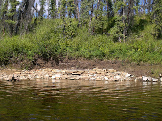


Interesting 'brick' rock formations


We finally got the GPS working for this trip. It was great to attach it to the back of our packs, positioned on the bow like a speedometer! We averaged about 3 mph on most of the river, and some of the shoots sped us up to 5 or 6 mph. It was also really helpful to have the GPS as a backup to our map reading, which is often hard on a winding river. I had set up 5 mile way-points, so we could easily chart our progress (although in later trips set way-points every mile).


Lunch was spent on a small gravel bar in the middle of the river, staring up at a bald eagle perched at the top of a tree on the bank opposite. They are such majestic creatures!


Bald eagle at our lunch spot


At about 4pm we reached a large switch-back and investigated the option of hiking up to the ridge from that point. It meant crossing a large area of burn covered in tussocks, each standing about two feet high. We tried walking just a few metres without the packs and realised it was just too dangerous (ankle breaking territory!). Tempting as it was to head straight for the hills, we instead trudged our way through a thick mud swamp which fed back into the river, and suffered the frustrating switch back.


Before too long we were on a gravel bar on the east side of Great Unknown Creek, our take out point. We had a long rest – it was an extremely hot day and we were both feeling the effects. Thankfully, it was cooler when we set out up the hill that would lead us to the long alpine ridgeline. It seemed there was no way to avoid tussocks, but at least the ones we encountered weren’t as big as the ones on the adjacent hill, and they didn’t last for too long. However, they did lead to a marsh! After a quick slog, we were soon on dryer ground and heading up the steep hill. As we crested the top and started down the other side towards a small drainage, a moose, startled by our presence, trotted across the stream and up the opposite hillside with envious ease. It covered in a few minutes what would take us about an hour! We filled up with water and continued on past the drainage to a precarious supper spot, perched among large sphagnum mounds.


Marielle at the precarious supper spot - we had to hold the pot whilst the water was heating, for fear of the dry vegetation catching on fire (whilst being bombarded by teams of hungry mosquitoes!)


We packed up and continued up the next forested hillside, which led to the alpine ridge, hoping to set up camp at the rocky section on top. But the hill was longer than we thought, and fairly exhausted we set up camp on a comfy sphagnum bed in amongst the trees.


DAY 3


View up the hill, morning of the third day


TY: We had slept soundly in our exhaustion on the deep, pillow bed of sphagnum moss before the heat of the morning sun drove us from the oven. While packing and hydrating, we hid from the climbing sun as well as we could before setting off. We reached the blessed alpine terrain after about two hours of soft moss, trees, and dense brush. The view opened up to reveal to the South and East the endless series of ridges and domes that characterize the Alaskan interior, fading in ever more ethereal shades of blue to the nebulous horizon. Our pace picked up from less than one mile per hour through the forest and brush to a walking speed of 3.5 mph and more according to our trusty GPS speedometer. Our spirits were high having reached this long-awaited terrain and we even jogged sections of easy downhill. The tradeoff however was the complete lack of protection from the violent sun in a mostly clear sky!


Almost at the alpine, but thick dwarf birch made the going tough for a bit longer...


We reach the alpine at last!


Marielle at the start of the long alpine section with "purple mountains majesty" in the background. God bless America.


We had to drop off the ridge for water, and luckily we found some at 3,000 ft, seeping from the ground and collecting in pools. We hydrated and trudged up 1,000 ft back to the ridge top with 5 liters in each backpack. After that we decided we did not want to do that again if we could avoid it – the detour for water had taken a couple of hours! We rationed water just enough to stave off headaches for the rest of the day. Much of the hiking was rocky and easy, where other sections were soft and mossy, making for a slow trudge.


Ty filtering water from a small pool of ground water


MARIELLE: Our progress along the ridgeline seemed impressive every time we looked back to see how distant our last rest spot had become. The sun was unrelenting though, with temperatures in the mid 90s. Almost every cloud that looked as if it might drift over the sun missed it, leaving us baking with no cover at all. Amazingly, we managed to stay relatively well hydrated, but the heat sapped our appetites and made it more and more difficult to eat our snacks.


Ty looking back at our route


I was becoming increasingly tired and getting worried about 'hitting the wall' again. About a mile before Mastodon Dome a caribou trotted into view and ran towards us. For a few moments both Ty and I were worried about its intentions, but it became obvious that it was just curious, and it soon trotted off. As with the moose, we marveled at the ease with which it traveled across the landscape - unlike our cumbersome footsteps. That encounter really brought me out of myself, back into the never-ending Alaskan alpine landscape, and the trudge, for a while, wasn't so bad.


Morale-boosting caribou!


Marielle gets lost in the expansive landscape


We had a scenic supper at the top of Mastodon Dome and decided to curtail our route. We had intended to go all the way to Eagle Summit and then ride our bikes (stashed in alder bushes) back to the car, but we were just too tired. We had noted a bail-out route, utilising a mining road which led from the base of an earlier ridgeline out to the Steese, and headed for this. We marched along the ridgeline and began our descent towards the road. As we neared the drainage at the base of the ridge, we spotted another caribou at the bottom. We slowed up and watched as it became aware of us; again, it came pretty close, us if interested to find out why two people were out hiking so late!


The mining road made easy hiking to the Steese, although after a long day, it seemed to go on and on. We reached the Steese at about 12.30pm, and somehow managed to get a lift back to our car - sitting in the bottom of a boat a pulled by a pickup truck! It was a bumpy ride, but we enjoyed the beautiful cool evening, and the thought of heading back to civilisation again!


The 'boat' ride home